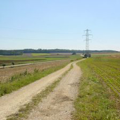
Hegau landscape
Continuity or change of prehistoric roads in the Hegau landscape, Konstanz District
 |
Background
Our little knowledge of the prehistoric cultural landscape is mainly characterised by accidental archaeological finds and rescue excavations. Systematic and area-wide field walking is time consuming and thus often limited to small-scale projects. This applies to the studies of ancient roads as well. The reconstruction of entire road networks is scarcely pursued and is usually carried out in the context of scientific studies. In these cases the available Site and Monuments Records are sufficient and are used as basis information for GIS based Predictive Modelling.
Objectives
With this ongoing doctoral dissertation project we explore a new approach to discover prehistoric routes by using classic methods of historical geography, theories of characteristic properties of roads and the modern tool of Predictive Modelling. Our objective is an extensive dataset of presumably ancient roads which holds information about the spatial setting, temporal classification, identified uncertainties and data quality. As a result, predictive archaeological areas around these road objects can be defined and used in local planning permission processes. Another objective is to choose the data sources and methods in such a way that the application to other areas is easily possible.
 |
Design and methodology
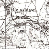
The first phase of work comprises the creation of a comprehensive dataset containing the road network of the Hegau landscape (Konstanz District) digitised area-wide from modern map sets of 1797 and 1848. Secondly, the theoretical characteristic properties of ancient tracks known by literature are summarised. Information about spatial orientation and wayfinding in modern Cognitive Science is added and transformed into GIS based algorithms. By applying these algorithms on the given 19th century roads we hope to identify presumably prehistoric road segments and anomalies in the third phase. Archaeological finds will finally be used to verify the selected objects thereby testing the new method.
May 2012 - Sep. 2016
Private funds
Claudia Rodat
Prof. Dr. Werner Konold, Prof. em. Dr. Hans-Rudolf Egli (Geographisches Institut, Universität Bern)
Kreisarchäologie Konstanz, Regierungspräsidium Freiburg, Referat 26 Denkmalpflege